Yesterday's rainfall: by the numbers
Yesterday's rain in some places was the heaviest seen for more than 50 years, Greater Wellington Regional Council's rainfall and river level monitoring equipment showed.
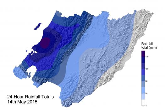
The heavy rain that affected the Wellington region from the Kāpiti Coast to Wellington city resulted in record rainfall totals and significant surface and river flooding.
Over the course of the day, rain gauges at MacKay's Crossing, Battle Hill and Tawa Pool recorded totals greater than the rainfall normally expected during the entire month of May.
A strong moist northwest flow funnelled an area of heavy rainfall and north westerly winds from the Tasman Sea over the lower North Island between the Kāpiti Coast and Wellington. The front contained numerous bands of heavy rain and pockets of thunderstorms that initially hit the Kāpiti Coast before slowly moving south east across Porirua, the Hutt Valley and Wellington.
Because the rainfall occurred in narrow bands, or as thunderstorms, some parts of the region were affected far worse than others.
On the Kāpiti Coast, MacKay's Crossing received a total of 145mm over 24 hours - the equivalent of a 1-in-40 year event at this location. However, rainfall further north in Otaki was insignificant, with the worst hit areas from about Te Horo southwards.
Regional Council Senior Analyst, Hydrology, Mike Harkness says the rainfall totals around the region were substantial.
"There are some very interesting and significant rainfall totals here. In some places on the Kāpiti Coast we're looking at the highest river levels since the floods of 1998.
"The 24-hour rainfall total at Battle Hill near Pauatahanui was equivalent to a 1-in-50 year event and in Porirua, the Porirua Stream had the largest flow since 1980.
"In the Hutt Valley, 42mm of rain was recorded in Avalon in just one-hour - that's estimated to be in excess of a 1-in-50 year event."
No damage occurred in the Hutt River. Extensive work in recent years has raised flood protection standards along the river and more is planned from the Hutt CBD south. No GWRC-managed stopbanks were breached throughout the region.
Greater Wellington Regional Council has 58 rainfall monitoring sites across the region that are used for flood warning purposes and 'state of the environment' monitoring. There are also 62 river monitoring sites where river level and flow is recorded.
Most of the rainfall and river sites are connected by telemetry so staff can monitor what is happening in real time. The rain gauges have alarm levels so that when heavy rainfall occurs an alarm is sent out to flood warning staff and the event can be tracked. The river sites also have alarms levels set to notify staff when dangerously high levels are being reached.
The Regional Council's Environmental Science department has put together a summary of the event. These are listed by geographic area below.
SUMMARY
KĀPITI
Heavy rain started to fall in the early hours of 14 May on the Kāpiti Coast with a total of 145mm recorded in 24 hours at McKay's Crossing. A rainfall total of this magnitude is expected once in every 40 years at this location. To the north, Waikanae received 102mm of rain in 24 hours which is expected once every 6 years. An intense burst of rain was recorded at Te Hapua Rd, south of Te Horo Beach, where 27mm fell in just one hour. This is equivalent to a 10 year event.
The Waikanae River peaked at a flow 270 cubic metres per second above SH1. This was the 3rd largest flow recorded since 1975 - only January 2005 and October 1998 were larger. A flow in the river of this size is expected once every 13 years.
The Wharemauku Stream turned into a raging torrent as it passed under SH1, and the recorded flow was only slightly less than that recorded during the October 1998 flood. Provisional data indicates this is likely to be in excess of a one in 20 year flood.
PORIRUA AND WELLINGTON
After initially hitting the Kāpiti Coast the rain band began to affect areas to the south. A number of rain gauge sites in the Porirua area recorded very heavy rainfall. At Battle Hill the most intense rain recorded was 30mm in one hour. Rainfall totals of 76mm and 144mm were recorded over 6 and 24 hour periods, equating to approximately one in 30 and 50 year events respectively. As a result of the intense rainfall the Horokiri Stream rose rapidly and reached its highest flow since 2003. The return period for yesterdays flow is estimated at 12 years.
The Porirua Stream peaked at a flow rate of 66 cubic metres per second which was the third largest flow seen there since the floods of 1976, and the largest since 1980. It ranks as the largest flood to have occurred since the Seton Nossiter and Stebbings flood detention dams were constructed in the upper catchment.
In addition to the Porirua Stream there was significant surface water flooding and many smaller streams also overtopped their channels. Rainfall was very intense with a very large total of 62mm of rain recorded at Tawa Pool in two hours. This intensity of rainfall is expected once every 40 years. A total of 115mm was recorded at Tawa Pool over 24 hours (a one in 20 year total).
HUTT VALLEY AND WAINUIOMATA
The rainfall band moved onto the Hutt Valley and Wainuiomata areas bringing a huge dumping of rain. In just one hour, 42mm of rain was recorded in Avalon which is estimated to be in excess of a 50 year event. Peak one hour rainfall totals at Shandon and Wainuiomata reached 33mm and 28mm respectively - expected every 10 to 30 years.
The Hutt River carried a large flow during the event but it only reached a level expected once in every two years. The Akatarawa River reached a similar level but all other major rivers draining to the Hutt River had insignificant flows. The Waiwhetu Stream and Wainuiomata River reached one in two year levels.
Over the course of the day rain gauges at McKay's Crossing, Battle Hill and Tawa Pool recorded totals of 145mm, 144mm and 115mm respectively - all of which are greater than the rainfall normally expected during the entire month of May.
ENDS
Media Contact:
021 914 266
Get in touch
- Phone:
- 0800 496 734
- Email:
- info@gw.govt.nz